Shrikhand Mahadev Trek: A Spiritual and Adventurous Himalayan Expedition
Explore Tours
About the Tour
The Shrikhand Mahadev Trek is one of the most challenging spiritual pilgrimages in the Indian Himalayas. Located at an altitude of 5,227 meters (17,150 feet) in Himachal Pradesh, this trek is not only a test of endurance but also a journey of faith and devotion.
The trek leads to the majestic 75-foot-tall Shivling, which is believed to be the abode of Lord Shiva. This sacred site is revered by Hindu devotees and adventure seekers alike, offering a unique blend of spirituality and high-altitude trekking.
Tour Description
- Region: Kullu, Himachal Pradesh
- Altitude: 5,227 meters (17,150 feet)
- Duration: 6-8 Days
- Trek Distance: 32 km (one way)
- Difficulty Level: Difficult
- Best Time to Visit: July to September
- Temperature:
- Day: 5°C to 15°C
- Night: -5°C to 5°C
- Start & End Point: Jaon Village
This trek requires immense physical stamina and mental determination due to its steep ascents, rocky terrain, and high-altitude exposure. The journey takes you through dense forests, meadows, glaciers, and moraines, with breathtaking views of the Himalayan ranges.
Tour Challenges
- Extreme altitude gain in a short duration.
- Steep and rocky trails with loose gravel.
- Unpredictable weather with sub-zero temperatures at night.
- Glacier crossings and high-altitude sickness risks.
- Lack of proper shelter and facilities after Bhim Dwar.
Tour Facilities
- Experienced trek leaders and local guides.
- Porters and mules for carrying common gear.
- High-quality camping gear (tents, sleeping bags, mats).
- Medical assistance with oxygen cylinders and first aid.
- Nutritious vegetarian meals.
FAQs
- How difficult is the Shrikhand Mahadev Trek? This is a highly difficult trek, suitable only for experienced trekkers.
- What is the best time to visit? July to September for stable weather and open trails.
- Will I experience altitude sickness? Yes, acclimatization is necessary to avoid AMS.
- Is there mobile network connectivity? Limited network in Jaon and Thachru, no network beyond Bhim Dwar.
Key Highlights
- One of the toughest spiritual treks in India.
- Magnificent Shrikhand Mahadev Shivling at 5,227 m.
- Panoramic Himalayan views and glacial lakes.
Embark on the ultimate spiritual and adventure trek to Shrikhand Mahadev!
Included/Exclude
Inclusions in the Tour Package
- Accommodation: Camps (Sharing Camp for two people), Home Stay.
- Guides & Support Staff: Qualified & experienced Trek Leader, Guide, and Support staff to assist trekkers.
- Sleeping Gear: Sleeping Bags.
- Meals: All meals during the trek (Breakfast, Packed Lunch, and Dinner – only vegetarian).
- Permits & Fees: Trekking Permits and Forest Fees.
- Trekking Equipment: Tent, Mattress, Sleeping Bag, Dining & Kitchen Tent, Toilet Tent, Cooking Utensils, and Crampons (if required).
- Medical Assistance: First aid medical kits and oxygen cylinder.
- Guide & Support Staff Expenses: Guide Allowances, Food, and Stay.
- Potters: Potters will carry only trekking equipment.
- Potter's Expenses: Allowances, Food, and Stay.
- Kitchen Staff: Included for cooking and meal preparation.
- Kitchen Staff Expenses: Allowances, Food, and Stay.
- Cook: Responsible for preparing meals.
- Cook's Expenses: Allowances, Food, and Stay.
- Transportation: As per the trek itinerary.
Exclusions in the Tour Package
- Any other facilities that are not mentioned in the inclusions.
- Potters for carrying your personal luggage.
- Extra meals like lunch during the journey by cab and stay at hotels (lunch is only provided during the trek).
- Personal expenses such as Water Bottles, Laundry, Phone Calls, etc.
- Insurance.
- Gaiters.
- Anything not specifically mentioned under "Inclusions."
Tour Amenities
Certified Trek Leader
Hassle-Free Permits
Warm Meals, Always
Itinerary
Overview
Drive Distance: 170 km from Shimla (approx. 6-7 hours)
Starting Altitude: 1,900 meters / 6,234 feet at Jaon Village
Detailed Plan
- Arrive at Jaon Village, the base camp for the Shrikhand Mahadev Trek.
- The village is accessible via a scenic drive from Shimla, passing through Rampur and Nirmand.
- Upon arrival, complete the registration process and attend a briefing about the trek.
- Overnight stay in tents or local guesthouses.
Overview
Trek Distance: 12 km (approx. 7-8 hours)
Starting Altitude: 1,900 meters / 6,234 feet at Jaon Village
Ending Altitude: 3,400 meters / 11,154 feet at Thachru
Detailed Plan
- Begin the trek with a gradual ascent through dense forests of pine and deodar.
- The trail follows the course of the Kurpan Gad (stream), offering refreshing views.
- After crossing the stream, the path becomes steeper, leading to the campsite at Thachru.
- Thachru is a meadow offering panoramic views of the surrounding peaks.
- Overnight stay in tents.
Overview
Trek Distance: 10 km (approx. 6-7 hours)
Starting Altitude: 3,400 meters / 11,154 feet at Thachru
Pass Altitude: 3,800 meters / 12,467 feet at Kali Ghati
Ending Altitude: 3,800 meters / 12,467 feet at Bhim Dwar
Detailed Plan
- Start early to tackle the steep ascent to Kali Ghati, a ridge offering 360-degree views of the Himalayas.
- The trail then descends slightly through alpine meadows adorned with wildflowers.
- Continue towards Bhim Dwar, a vast meadow believed to be associated with the Pandava prince Bhima.
- The area is dotted with unique rock formations and offers a serene environment.
- Overnight stay in tents.
Overview
Trek Distance: 5 km (approx. 4-5 hours)
Starting Altitude: 3,800 meters / 12,467 feet at Bhim Dwar
Ending Altitude: 4,500 meters / 14,764 feet at Parvati Bagh
Detailed Plan
- The trail ascends gradually, with the landscape becoming more rugged and rocky.
- En route, pass by small streams and patches of alpine flowers.
- Parvati Bagh is a high-altitude meadow known for its variety of Himalayan flora, including rare flowers like the Brahma Kamal.
- The campsite offers close-up views of the towering peaks.
- Overnight stay in tents.
Overview
Trek Distance: 12 km (approx. 10-12 hours)
Starting Altitude: 4,500 meters / 14,764 feet at Parvati Bagh
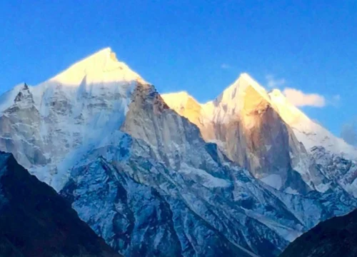
Summit Altitude: 5,227 meters / 17,150 feet at Shrikhand Mahadev Peak
Ending Altitude: 3,800 meters / 12,467 feet at Bhim Dwar
Detailed Plan
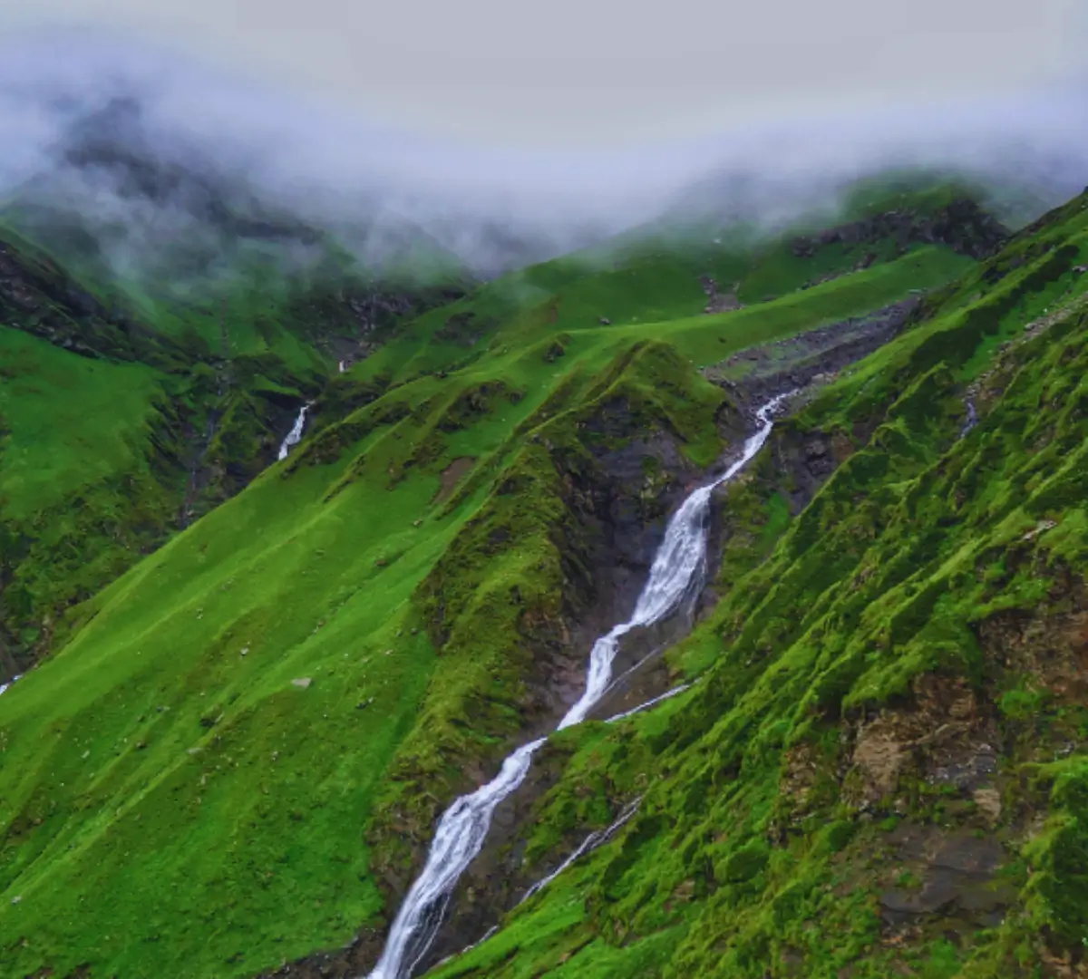
- Begin the summit attempt early, navigating through rocky terrains and glacial moraines.
- The trail passes by Nain Sarovar, a sacred lake situated at 4,300 meters (14,107 feet).
- After a brief halt at the lake, continue the steep ascent to the Shrikhand Mahadev peak.</ p>
p> - Upon reaching the summit, witness the majestic 75-foot tall Shivling rock, a sacred symbol of Lord Shiva.
- Spend some time at the summit, offering prayers and soaking in the breathtaking panoramic views of the Himalayas.
- Begin the descent carefully, retracing your steps to Parvati Bagh and then further down to Bhim Dwar.
- Overnight stay in tents at Bhim Dwar.
Overview
Trek Distance: 10 km (approx. 5-6 hours)
Starting Altitude: 3,800 meters / 12,467 feet at Bhim Dwar
Ending Altitude: 3,400 meters / 11,154 feet at Thachru
Detailed Plan
- Descend along the same scenic route, passing through the alpine meadows and rocky landscapes.
- Cross Kali Ghati ridge once again, enjoying the final panoramic views before heading into the lower forests.
- Arrive at Thachru, where you will set up camp for the night.
- Overnight stay in tents.
Overview
Trek Distance: 12 km (approx. 5-6 hours)
Drive Distance: 170 km to Shimla (approx. 6-7 hours)
Starting Altitude: 3,400 meters / 11,154 feet at Thachru
Ending Altitude: 1,900 meters / 6,234 feet at Jaon Village
Detailed Plan
- Begin the final leg of the trek, descending through dense pine and deodar forests.
- Reach Jaon Village by afternoon, marking the completion of the Shrikhand Mahadev Trek.
- Bid farewell to fellow trekkers and take a drive back to Shimla or your onward destination.
Important Notes
- Best Time to Visit: The trek is open from July to early September, coinciding with the annual pilgrimage.
- Difficulty Level: Challenging – Requires high endurance and prior trekking experience.
- Weather Conditions: Daytime temperatures range from 10°C to 20°C, while nighttime temperatures can drop to -5°C at higher altitudes.
- Permits: Registration with local authorities is mandatory before starting the trek.
- Acclimatization: Proper acclimatization is crucial due to high altitudes.
- Network Connectivity: Limited mobile connectivity after Jaon Village.
- Essential Gear: Sturdy trekking shoes, warm clothing, waterproof gear, trekking poles, headlamp, and high-energy snacks.
- Eco-Friendly Trek: Follow the Leave No Trace principle – respect nature, avoid littering, and minimize plastic usage.